Hydrographic Features
Physical components related to water bodies (rivers, lakes, seas, etc.) represented in GIS for spatial analysis of aquatic environments.
What does the term Hydrographic Features refer to?
The natural and man-made components associated with water bodies on the surface of the Earth are referred to as hydrographic features. Rivers, lakes, streams, marshes, reservoirs, canals, and coastal regions are some examples of these features.
Features of hydrography are crucial for:
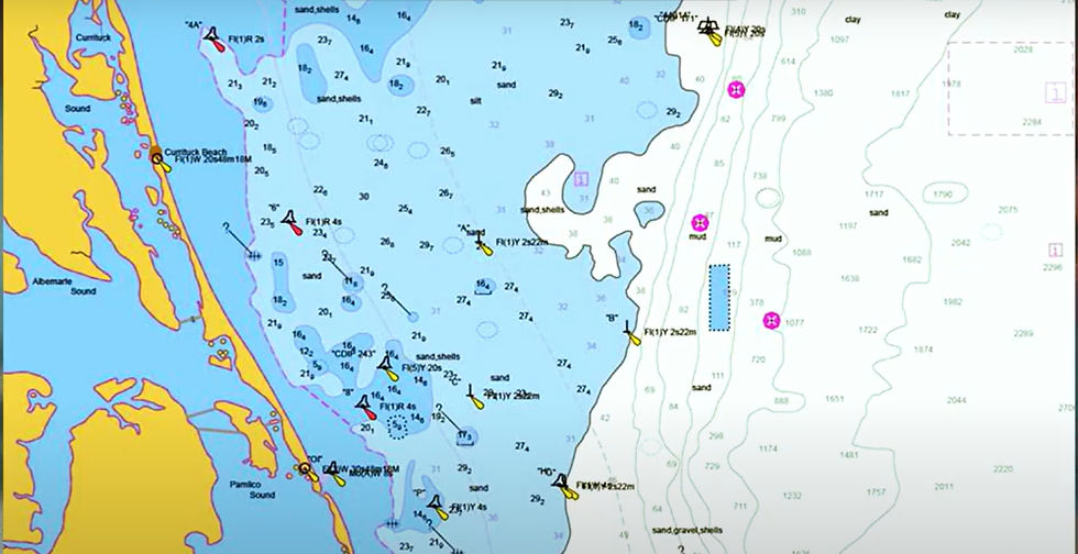
Marine mapping and navigational charts
Management of water resources
Observation and preservation of the environment
Land use planning and flood risk assessment
Planning human activities around water bodies, maintaining ecosystems, and managing water systems are all made easier with an understanding of hydrographic features.
For more information or any questions regarding our services, please don't hesitate to contact us at
Email: info@geowgs84.com
USA (HQ): (720) 702–4849
India: 9009471866 - Jay Sharma
Canada: (519) 590 9999
Mexico: 55 5941 3755
UK & Spain: +44 12358 56710
In order to ascertain depth, seabed features, and underwater topography, hydrographic survey procedures entail measuring and mapping bodies of water. LiDAR bathymetry for shallow waters, side-scan sonar for seabed imaging, and single-beam and multi-beam echo sounding for depth determination are common methods. While data is processed to create nautical charts, facilitate navigation, and support marine research and coastal engineering, GPS and GNSS systems guarantee accurate positioning.
In order to facilitate navigation, research, and resource management, bathymetric mapping uses methods such as LiDAR, satellite data, and sonar (multibeam/single-beam) to survey underwater terrain.
Hydrographic features are aspects of Earth's water bodies that are both natural and man-made. Along with coastal characteristics like bays, inlets, and beaches, they also include rivers, lakes, ponds, streams, canals, reservoirs, wetlands, estuaries, and oceans. Environmental studies, mapping, navigation, and water resource management all depend on these properties.
Navigation safety, coastal engineering, flood risk management, and environmental monitoring all depend on hydrographic data, which contains details about water bodies, depths, tides, currents, and seabed features. It facilitates port development, offshore building, habitat preservation, and marine route design, allowing for precise decision-making and long-term aquatic resource management.