


Trusted by Industry Leaders


Our Mission
Empowering innovation with GeoAI by making spatial intelligence accessible and impactful for smarter decisions and sustainable global development.
At GeoWGS84.ai, we specialize in advancing geospatial intelligence through the integration of Artificial Intelligence and spatial data science. We develop cutting-edge online tools, models, and workflows that harness the power of GeoAI to solve real-world problems across domains such as urban planning, agriculture, disaster response, climate monitoring, transportation, and more.
Our platform offers:
-
Cloud-based GeoAI solutions for spatial analysis and predictive modeling
-
Online annotation and visualization tools for geospatial data
-
Custom consulting and project support for organizations implementing Geospatial AI
We bridge the gap between traditional GIS and modern AI, making location intelligence smarter, faster, and more scalable.

GeoWGS84.ai: Cloud-Based Remote Sensing & Geospatial Raster Analysis
Learning the world, one model at a time

Segment Anything Model

Tree Point Classification

Pedestrian Infrastructure Classification

Wildfire Delineation

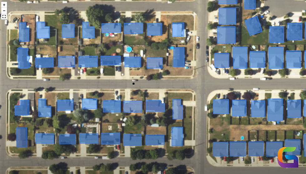
Building Footprint Extraction

Pavement Crack Detection
Innovation In Flight
Our state-of-the-art drones and AI-powered analytics deliver accurate, real-time data for informed environmental decisions
Use this space to promote the business, its products or its services. Help people become familiar with the business and its offerings, creating a sense of connection and trust.


Automated Spatial Analysis
GeoAI reduces human labour by leveraging AI/ML to automate pattern recognition and feature extraction from imagery.
Predictive and Prescriptive Analytics
GeoAI forecasts trends and optimizes processes like site selection and routing by fusing spatial data with machine learning.
High-Resolution Insights at Scale
Large geospatial datasets, such as LiDAR, are analyzed by GeoAI to provide in-the-moment, comprehensive insights for improved decision-making.
Enhanced Decision Support Across Domains
GeoAI improves the speed and precision of geographical decision-making across industries.
Gain a Competitive Edge with GeoWGS84.ai

Our Impact
500K
Acres
Surveyed
98%
Client
Satisfaction Rate
30%
Average Resource Savings for Clients
5M
Data Points
Collected Daily


Aerial Perspectives
Let's Elevate Your Data
Ready to unlock the power of aerial environmental intelligence?