Active vs Passive Sensing in Remote Sensing: Key Differences and Applications
- Jan 26
- 3 min read
Updated: Apr 14
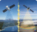
Geospatial science relies heavily on remote sensing as a technology that allows us to monitor, measure, and assess the Earth's surface without physically being there (through Satellites, Climate Monitoring, Urban Planning and Disaster Management). Two main technologies or types of remote sensing include: Active and Passive Remote Sensing.
It is important to understand how both Active and Passive Remote Sensing operate to choose the appropriate data, sensor, and analysis method for any application. In this article, you will learn more about how each of these types of sensing operates, their differences, strengths, weaknesses, and examples of use in practice.
What Is Remote Sensing?
Remote sensing is a science that involves gathering information about a subject or object from a location that is not in direct contact with the subject or object. Remote sensors typically use aircraft, satellites, drones, or ground-based sensors to collect information about a subject or object. Remote sensing systems can detect and measure the electromagnetic energy that is reflected from or emitted from the surface of the Earth to the satellite or other terminal.
Remote sensing technologies have been extensively applied to:
GIS and Geographic Information Systems
Environmental Monitoring
Agriculture and Forest Management
Defense and Intelligence Operations
Research on Weather and Climate
Passive Remote Sensing
How Passive Remote Sensors Operate
Passive remote sensors detect naturally occurring energy emitted from or reflected off a subject's or object's surface.
Passive sensors do not provide their own energy source; rather, they use the energy in the surrounding environment to obtain measurements.
Examples of Passive Remote Sensing Systems
NASA Landsat
European Space Agency Sentinel-2
MODIS
WorldView optical satellites
Advantages of Passive Remote Sensing
High spectral resolution
Excellent for Vegetation and Land Cover Analysis
Long-Term Historical Data Archived
Generally requires less energy to operate.
Disadvantages of Passive Remote Sensing
Sunlight Dependent (Limited Night Vision)
Weaknesses Associated with Atmospheric Conditions (Clouds, Haze, etc.)
Significantly Reduced Performance in Polar Regions During Winter
Active Sensing in Remote Sensing
How Active Sensors Work
Active sensors emit their own electromagnetic energy toward the Earth’s surface and measure the reflected or backscattered signal. Because they provide their own illumination source, they can operate independently of sunlight.
Common Active Sensors
Synthetic Aperture Radar (SAR)
LiDAR (Light Detection and Ranging)
Radar altimeters
Examples of Active Remote Sensing Systems
Sentinel-1 (SAR)
RADARSAT
TerraSAR-X
Airborne and spaceborne LiDAR systems
Advantages of Active Sensing
Operates day and night
Can penetrate clouds, smoke, and light rain (especially radar)
Highly accurate elevation and surface structure data
Effective in all weather conditions
Limitations of Active Sensing
Higher system complexity and cost
Typically, lower spectral detail compared to optical sensors
Radar data can be harder to interpret without specialized expertise.
The application of passive sensing units
Passive remote sensing provides information about surface reflectance as well as various spectral bands at once. Examples of passive remote sensing applications include:
Land Use and Land Cover Mapping
NDVI (Normalized Difference Vegetation Index) and EVI (Enhanced Vegetation Index) Vegetation Health Monitoring
Agricultural Crop Assessment
Climate Change Evaluation
Ocean Colour and Water Quality Monitoring
Urban Growth Studies
Active Sensing Applications
When light levels are poor or other adverse weather conditions exist, active remote sensing can provide an accurate measurement of objects. Examples of Active Remote Sensing Applications include:
Flood/Disaster Monitoring
Soil Moisture Estimation
Infrastructure/Deformation Monitoring (InSAR)
Forest Structure/Biomass Estimation
Ice/Snow/Polar Studies
Both active and passive sensing are essential pillars of remote sensing technology. Passive sensing offers rich spectral information ideal for environmental and land analysis, while active sensing provides all-weather, day-and-night capabilities crucial for terrain, structure, and disaster monitoring.
Choosing the right sensing approach—or combining both—depends on your application, environmental conditions, and analytical goals.
As remote sensing continues to evolve with AI-driven analytics and high-resolution sensors, understanding these core concepts remains vital for geospatial professionals, researchers, and decision-makers.
For more information or any questions about active and passive sensing, please don't hesitate to contact us at
Email: info@geowgs84.com
USA (HQ): (720) 702–4849
(A GeoWGS84 Corp Company)