
NDWI: Normalized Difference Water Index Explained
Water is one of the crucial resources on the planet. Its observation and management are vital in the realms of environmental management, agriculture, urban planning, and disaster management. Thanks to the advancements in satellite and remote sensing technologies, it is now possible to identify and analyze water bodies over a large geographical area without ground surveys.
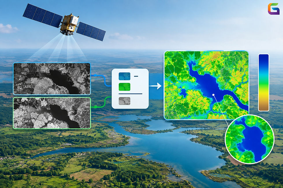
The Normalized Difference Water Index (NDWI) is one of the most frequently employed indices of remote sensing that allows for water detection and monitoring. NDWI utilizes the spectral properties of water expressed in different bands in order to identify water bodies and differentiate water from vegetation, soil, and built-up areas.
The input required for calculating NDWI may be obtained through satellite remote sensing, and NDWI may be used along with GIS, resulting in the development of water maps that are measured over time.
What Is NDWI?
NDWI, or Normalized Difference Water Index, is a type of spectral index that helps to make water features stand out in satellite or aerial photos. There are different ways of calculating NDWI. However, the most commonly used equation is:
NDWI = (Green - NIR) / (Green + NIR)
This formula produces values that are usually within the range of -1 to +1.
Normally, water has a high reflectance in the green portion of the spectrum while absorbing almost all of the near-infrared. As a result, water pixels will usually have a much higher NDWI reading than the rest of the land surface.
NDWI is very effective in detecting rivers, lakes, reservoirs, ponds, etc.
How Does NDWI Work?
NDWI functions by making the most of the differences in the materials' abilities to reflect and absorb the electromagnetic rays of energy.
Compared to vegetation as well as other surface bodies on land, water behaves differently at different wavelengths. For example, while water shows measurable spectral reflectance in the visible spectrum, it absorbs virtually all the radiation in the near-infrared range.
This is summarized in the NDWI equation:
Green wavelength: Generally, water has a higher spectral reflectance.
NIR wavelength: Water absorbs most of the rays, which results in low reflectance values.
NDWI: The contrasting values across the two wavelengths will accentuate the water pixels.
With regard to vegetation, it is normally very reflective in the infrared range, leading to low or negative NDWI values when it is mixed with water.
Due to the fact that NDWI is normalized, it is less sensitive to the differences in the overall brightness of the image compared to using a standard band subtraction method.
NDWI Formula
The standard NDWI formula is:
NDWI = (Green − NIR) / (Green + NIR)
Where:
Green = Reflectance in the green spectral band
NIR = Reflectance in the near-infrared spectral band
For example, if a pixel has a green reflectance of 0.20 and an NIR reflectance of 0.05:
NDWI = (0.20 − 0.05) / (0.20 + 0.05)
NDWI = 0.60
A relatively high positive value suggests that the pixel is likely associated with water.
However, NDWI values should not be interpreted using one universal threshold for every dataset. Sensor characteristics, atmospheric conditions, water turbidity, surrounding land cover, shadows, and image processing can affect the resulting values.
How to Calculate NDWI
The steps of NDWI calculation may comprise many processes, as follows:
Collect Multispectral Data
Initially, information can be acquired by collecting data from satellite or aerial images that encompass bands of the green and NIR spectrum.
Prepare the Data
The process of preparing the multispectral data may involve:
Atmospheric correction
Removal of cloud and shadow
Calibration of energy data
Alignment of the images
Mosaicking of the images when required
All these procedures will ensure the validity and reliability of NDWI calculation.
Select Green and NIR Bands
Choose the right green and NIR bands for the selected sensor.
Because the band numbers differ across satellites, it is necessary to determine the specific bands of the sensor prior to executing the calculation.
Calculate NDWI Using the NDWI Equation
Calculate the NDWI for each pixel:
NDWI = (Green - NIR) / (Green + NIR)
This will generate a raster showing the NDWI value for every valid pixel.
Apply a Water Threshold
The NDWI raster can then be classified using an appropriate threshold that will classify water from non-water.
For example, pixels greater than a chosen threshold can be classified as water.
However, the ideal threshold must be derived from the image properties and the study area and not set for all projects.
Conduct GIS Analysis
This NDWI raster output will be used within GIS software to carry out tasks such as:
Water body extraction
Area calculation
Change detection
Map generation
The water bodies obtained can also be overlaid with roads, administrative boundaries, land use maps, and elevations, among others.
NDWI and GIS
NDWI becomes even more valuable when combined with GIS (Geographic Information Systems).
An NDWI raster image may be layered with other spatial data to address such issues as:
How much has the reservoir changed?
Which farms lie close to the surface water?
Which routes or buildings have been flooded?
How much has a particular wetland changed within several years?
Which water bodies can be found within a certain administrative unit?
GIS tools can also transform classified NDWI rasters to vector polygons, calculate water body sizes, do spatial statistics, and produce maps.
NDWI with Python
NDWI can be calculated programmatically in Python geospatial libraries as well.
Such libraries as Rasterio, NumPy, GeoPandas, and GDAL may be used for automated remote sensing workflows.
A typical workflow in Python is as follows:
Loading the green and NIR bands of the raster image.
Conversion of data to numerical arrays.
Applying the NDWI formula.
Dealing with NoData and invalid pixels.
Storing the resulting NDWI raster.
Classification of the NDWI raster according to the chosen threshold value.
GIS processing.
Automation becomes especially helpful when processing huge collections of satellite imagery.
NDWI stands for the Normalized Difference Water Index and represents a convenient tool for detecting and monitoring surface water through remote sensing.
It is employed in a variety of tasks such as the mapping of water bodies, flood assessment, wetlands monitoring, and agricultural water management, among others.
Using GIS, satellite images, Python programming, and other remote sensing tools, the NDWI may become an integral part of a workflow of automatic geospatial analysis.
Yet, the NDWI outcomes should be approached with caution because several factors, including sensor type, atmospheric conditions, turbidity, presence of vegetation, shadows, and urban areas, may affect the outcome of the NDWI application.
For that reason, the NDWI requires appropriate preprocessing, threshold validation, and geospatial data usage.
For more information or any questions regarding NDWI, please don't hesitate to contact us at
Email: info@geowgs84.com
USA (HQ): (720) 702–4849
(A GeoWGS84 Corp Company)


Comments