
Land Cover Classification for Accurate Geospatial Analysis
Land cover classification is a crucial procedure in remote sensing and geographic information systems (GIS), helping identify and map the physical substances present on Earth's surface. Such land cover types may include forest cover, agricultural fields, water resources, urbanized territories, grasslands, bare ground, and many others.
By converting satellite images, aerial photos, and drone photos into maps of classified land cover types, GIS specialists can study how landscape structure looks and how it evolves. Contemporary procedures of land cover classification often use multispectral images, machine learning, and deep learning techniques.

What Is Land Cover Classification?
Land cover classification involves the allocation of individual pixels, image objects, or geographic areas into known classes of land cover according to the spectral, spatial, temporal, or textural properties of the images.
For example, an image from a multispectral satellite can be classified into land cover types such as:
Forest
Agricultural land
Urban/built-up areas
Water
Grassland
Bare soil
Wetlands
Snow/ice
The output classification raster can then be incorporated into GIS processes.
How Does Land Cover Classification Work?
A normal land cover classification process is usually made up of the following steps:
Acquisition of Remote Sensing Data
The process starts by identifying suitable data depending on the geographical location, resolution, spectral bands, time series, and other factors.
Examples of remote sensing data sources include:
Multi-spectral satellite images
Hyperspectral images
Aerial Images
UAV Images
Synthetic aperture radar (SAR)
Digital elevation models (DEM)
Multi-spectral images are very helpful since they respond to the electromagnetic spectrum in different ways due to different land covers.
Preprocessing of the Imagery
Raw imagery might require some preprocessing prior to classification. Such preprocessing techniques include atmospheric correction, radiometric calibration, geometric correction, orthorectification, cloud masking, and image mosaicking.
For satellite imagery, cloud and cloud shadow masking are particularly important since pixels contaminated with clouds can result in erroneous classifications.
Further, other preprocessing techniques might be employed. They include reprojection, resampling, normalization, and deletion of NoData pixels.
Select Relevant Features
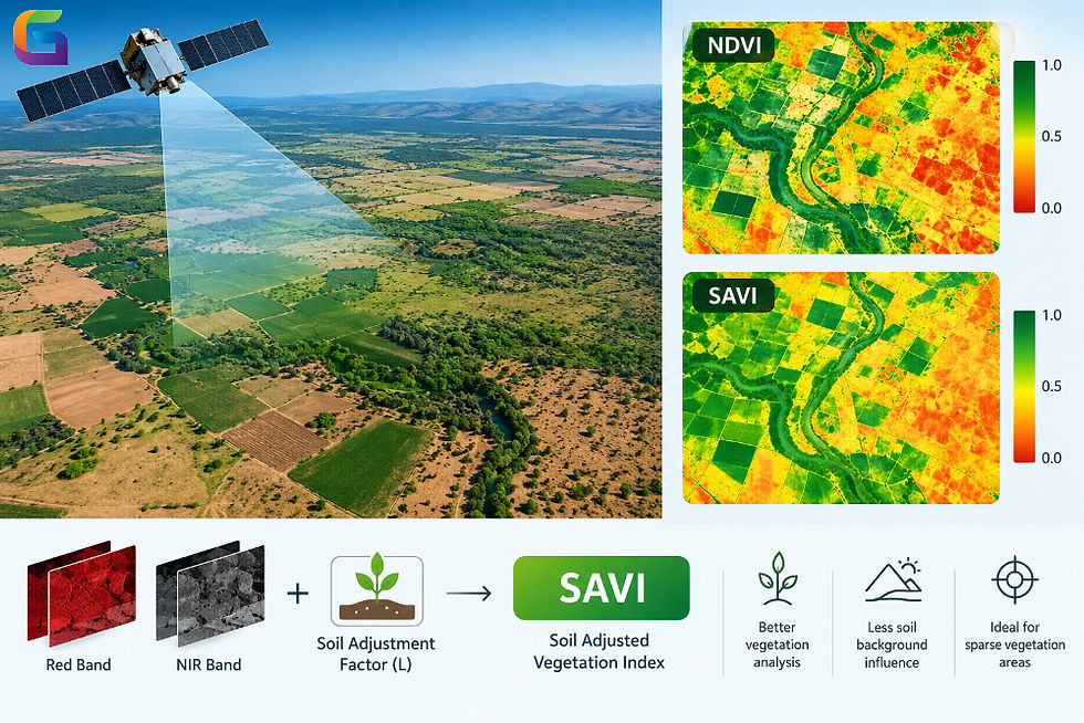
Classification models do not have to be based solely on the original spectral bands. Derived remote sensing indices and spatial features may be used as additional features.
Some commonly used features are:
Define Training Data
The supervised classification method is based on the availability of representative training samples for each land cover class. Such training samples may be created through field surveys, existing databases on land cover, manual interpretations of images, and high-resolution reference data.
The training samples must encompass all the variation in geography and spectral characteristics of each class. Otherwise, a lack of sufficient and properly distributed training data will negatively affect the generalization of the classification model.
Apply a Classification Algorithm
This algorithm determines which classes each pixel/object belongs to.
Among classical machine learning algorithms, there are:
Random Forest
Support Vector Machine (SVM)
k-Nearest Neighbors (k-NN)
Decision Trees
Maximum Likelihood Classification
Among deep learning algorithms, one may apply CNNs (Convolutional Neural Networks), encoder-decoder networks, and transformers.
Validate the Classification
The accuracy of classification needs to be assessed on the basis of independent validation samples and not just training samples.
A confusion matrix can be employed to validate the predicted class against the reference class. The commonly used classification accuracy measures are:
Overall Accuracy
Producer’s Accuracy
User’s Accuracy
Precision
Recall
F1 score
Intersection over Union (IoU)
For multi-class land cover classification, class-level measures are especially useful as the overall accuracy measure may be misleading.
Machine Learning for Land Cover Classification
Machine learning has emerged as an integral part of land cover mapping.
Random Forest
Random Forest is a combination of several decision trees and can capture nonlinear relationships between spectral and environmental variables. It is usually successful at multispectral classification and can process rather large sets of features.
Support Vector Machine
SVM classifies data by determining the decision boundaries in the feature space. It can successfully deal with high-dimensional remote sensing data and insufficiently large sets of training data.
Deep Learning
Deep learning algorithms can directly learn the spatial and spectral patterns from images. The CNN-based architectures are widely applied in image classification and segmentation tasks.
Deep learning is especially useful for high-resolution datasets containing objects like buildings, roads, vegetation, and cultivated areas.
GeoAI and Automated Land Cover Classification
With the advent of geospatial data combined with artificial intelligence technology, there are now many more automated land cover classification procedures available.
GeoAI algorithms can analyze a huge amount of imagery from satellites, airplanes, and drones to detect patterns that cannot be extracted manually. Deep learning segmentation algorithms can create pixel-level or object-level predictions for certain land cover classes.
Typical procedure within the framework of GeoAI could consist of:
Remote sensing imagery → pre-processing → feature extraction → model inference → classification map → accuracy assessment → GIS analysis
Another option for scaling up would be cloud-based processing, as it allows analyzing a huge collection of imagery without the need to keep everything local.
Challenges in Land Cover Classification
There are still a number of difficulties that may arise despite advancements in machine learning and remote sensing technologies.
Spectral Similarities
Land cover classes could have identical spectral reflectance characteristics. For example, it could be hard to differentiate between concrete, bare soil, and certain dry vegetation using limited spectral information.
Mixed Pixels
More than one land cover class could be represented within a single pixel in case imagery resolution is relatively low.
Seasonal Changes
Vegetation and crops change over time. Consequently, a machine learning model trained on imagery captured during one season will work worse in a different season.
Atmospheric Effects
Clouds, shadows, and haze may impact the measurements and create errors in the classification process.
Quality of Training Data
Models are very dependent on quality training data. Inaccurate class labeling, class imbalance, and insufficient geographic variability of training data may lower the effectiveness of a model.
Spatial Generalizability
Machine learning models trained for one geographic location might prove ineffective in another due to different land cover, climate, soils, vegetation, and imaging conditions.
How to Improve Classification Accuracy
The following steps may enhance the accuracy of the land cover classification process:
Employing imagery with the required spatial and spectral resolution.
Conducting appropriate radiometric and atmospheric corrections.
Eliminating clouds and cloud shadows.
Using training samples that are representative and properly labeled.
Including pertinent spectral indices and spatial variables.
Utilizing multiple temporal imagery for landscapes that vary by season.
Balancing classes before model training.
Using validation datasets.
Analysing confusion matrices and class-wise metrics.
Comparing classification output with high-resolution reference imagery or ground truth observations.
Choosing the Right Classification Method
There is no general classification technique that applies to all remote sensing applications. The proper classification technique depends on a variety of factors including the data, geographic conditions, the classification scheme used, the amount of training data available, computing capabilities, and accuracy requirements.
In the case of smaller multispectral data sets, machine learning approaches would work well. If high-resolution data and complex spatial relationships are considered, then object-based techniques would be preferable.
The classified result must always be tested using independent reference data prior to any significant spatial analyses.
Classification of land cover transforms intricate remote sensing images into geographical data that can be processed using GIS. Through the use of satellite and aerial images, along with image processing techniques, spectral indices, machine learning, deep learning, and accuracy assessment, companies can create detailed land cover maps for monitoring, agriculture, urban planning, forestry, and disaster management.
With the continued increase in geospatial data, the need for automated classification and GeoAI becomes more and more essential for effective processing of image libraries and maintaining accurate spatial data. The essence of accurate processing is still a combination of proper images, proper training data, the right algorithms, validation, and geospatial processing.
For more information or any questions regarding Land Cover Classification, please don't hesitate to contact us at
Email: info@geowgs84.com
USA (HQ): (720) 702–4849


Comments