
NDVI vs NDWI vs NDBI vs SAVI: Remote Sensing Guide
Remote sensing indices are calculations performed on multispectral satellite and aerial imagery that help analyze specific properties ofEarth’s surface. Some of the most commonly used indices include the Normalized Difference Vegetation Index (NDVI), Normalized Difference Water Index (NDWI), Normalized Difference Built-up Index (NDBI), and Soil Adjusted Vegetation Index (SAVI).
While these indices operate on similar normalized-difference principles, each is used to analyze a particular form of land cover. It becomes important to know the difference between NDVI, NDWI, NDBI, and SAVI when dealing with satellite images.

What is NDVI?
The Normalized Difference Vegetation Index (NDVI) is one of the most widely applied vegetation indices in remote sensing technology. This index indicates the relative vegetation density and vigor by using the red-near-infrared radiation difference.
Healthy vegetation absorbs much red radiation due to chlorophyll content but reflects more near-infrared radiation due to the plant structure.
The standard NDVI formula is:
NDVI = (NIR − Red) / (NIR + Red)
The NDVI values normally vary from -1 to +1. Positive values usually indicate more intensive vegetation, while zero or negative values may indicate soil surface, water body, snow cover, cloudiness, or urban areas.
Common NDVI Applications
Crop monitoring
Monitoring of vegetation health status
Forest monitoring
Drought assessment
Land cover mapping
Biomass estimation
Environmental monitoring
For example, comparison of the NDVI values for different dates provides information on vegetation conditions in the course of the growing season.
What Is NDWI?
The Normalized Difference Water Index (NDWI) is mainly used to detect and monitor water features and surface-water conditions. Various formulations of NDWI are available, and the bands used may depend on the application and sensor.
A popular formula for detecting water features is:
NDWI = (Green – NIR) / (Green + NIR)
Generally, water reflects green waves more strongly than NIR waves, while vegetation and most land surfaces reflect more NIR than green.
This index can be used to differentiate between water features and surrounding land surfaces.
Common NDVI Applications
Detecting lakes and reservoirs
Detecting rivers and wetlands
Flood mapping
Surface water monitoring
Coastal studies
Detection of changes in water bodies
NDWI is especially useful in studying changes in surface water using multispectral imagery.
What is NDBI?
The Normalized Difference Built-Up Index (NDBI) is an index that aims to map built-up areas through multispectral imagery. The basis of the index is the difference between SWIR and NIR reflectance.
The formula that is usually applied is:
NDBI = (SWIR − NIR) / (SWIR + NIR)
Materials such as concrete, asphalt, and other urban structures have spectral signatures that allow this index to separate the urban land cover from other types of land cover.
Common NDBI Applications
Urban area extraction
Mapping of built-up areas
Urban expansion analysis
Land use and land cover studies
Monitoring of urban growth
Regional development analysis
Change detection
NDBI can be very helpful when working with satellite images for different time periods to detect changes in urban land cover.
What Is SAVI?
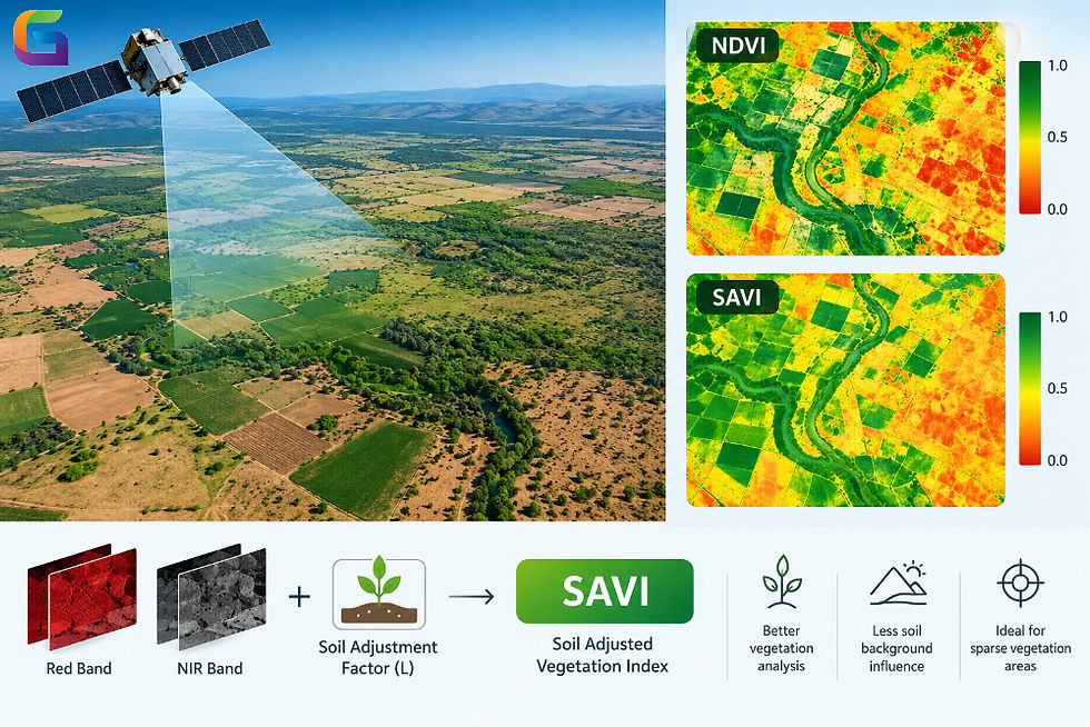
The Soil Adjusted Vegetation Index (SAVI) is a vegetation index designed to minimize the impact of soil exposure on the measurement of vegetation. Thus, the usefulness of SAVI lies in its ability to be applied in those cases where there is low vegetation cover and a lot of soil exposure.
The generally accepted equation for SAVI is:
SAVI = [(NIR − Red) / (NIR + Red + L)] × (1 + L)
In this equation, L is a soil correction parameter. A commonly used parameter is 0.5; however, the optimal value depends on vegetation density and site conditions.
Common NDBI Applications
Mapping of sparse vegetation
Monitoring of agriculture
Analysis of dryland vegetation
Studies of semi-arid landscapes
Crop monitoring
Analysis of vegetation in exposed soil sites
As compared with NDVI, SAVI gives a more soil-adjusted picture of vegetation in landscapes that have a lot of bare land.
NDVI vs NDWI vs NDBI vs SAVI
The primary difference between these four remote sensing indices is their target feature and spectral bands.
Index | Full Name | Primary Target | Common Bands |
NDVI | Normalized Difference Vegetation Index | Vegetation | NIR and Red |
NDWI | Normalized Difference Water Index | Water | Green and NIR* |
NDBI | Normalized Difference Built-up Index | Built-up areas | SWIR and NIR |
SAVI | Soil Adjusted Vegetation Index | Vegetation with soil influence | NIR and Red |
NDWI has multiple formulations. Another widely used approach, particularly for vegetation-water content studies, uses NIR and SWIR bands.
The choice of index should therefore be based on the feature being investigated, the sensor's available spectral bands, and the characteristics of the study area.
Which Remote Sensing Index to Choose?
There is no such index that is applicable in all cases of remote sensing applications.
Choose NDVI in case vegetation assessment is the main goal and you require a well-known index of vegetation state.
Choose NDWI in case your analysis is aimed at surface water identification. In this case, the proper NDWI variant has to be chosen based on the goal and spectral bands available.
Choose NDBI in case you aim to identify built-up surfaces or analyze urbanization.
Choose SAVI in case the vegetation is not dense enough, and soil can exert a considerable effect on the spectral reflectance.
In some cases, the use of several indices together can bring more information than using a single index. For example, NDVI can describe vegetation state, NDBI can identify built-up areas, and NDWI can detect water.
Spectral Bands Matter
The accuracy of the remote sensing index depends in part on the spectral bands that are available for the particular satellite or airborne sensor being used. The different sensors have different band locations and resolutions; therefore, the spectral band choice needs to be confirmed prior to computing an index.
For example, the remote sensing process of using the data collected by the Sentinel-2 satellite will employ different band selections and spatial resolutions compared to the Landsat images.
Before computing an index, the following aspects should be considered:
Satellite sensor and platform
Wavelengths of the spectral bands
Spatial resolution
Radiometric resolution
Atmospheric correction
Cloud/cloud-shadow masking
Date when the image was acquired
Seasonal conditions
Limitations of NDVI, NDWI, NDBI, and SAVI
The remote sensing indices are valuable tools of analysis, but their values cannot be evaluated without taking into account the environmental and sensor-specific conditions.
NDVI becomes less sensitive in highly vegetated regions and is influenced by soils and atmospheric factors. NDWI is influenced by vegetation, shadows, soils, and other land surface types according to the particular formulation. NDBI may generate some vague values since some soils can have the same spectra as built-up surfaces. Although SAVI minimizes the background effects due to soils, its value is determined by the proper choice of bands and soil adjustment factor.
Therefore, the index-based approach is usually applied together with classification methods, spectral analysis, field surveys, or other remote sensing data.
NDVI, NDWI, NDBI, and SAVI are crucial indices that aid in the extraction of information from the multispectral remote sensing data. The main purpose of NDVI is vegetation; NDWI is mostly employed in water-related studies; NDBI is used to identify areas of built-up surfaces, while SAVI is used to eliminate the effects of soil background during vegetation studies.
The choice of an appropriate index depends on knowledge about the features of interest, the spectral properties of the area under study, the available bands of the sensor, and other environmental factors.
For more information or any questions regarding NDVI, NDWI, NDBI, and SAVI, please don't hesitate to contact us at
Email: info@geowgs84.com
USA (HQ): (720) 702–4849
(A GeoWGS84 Corp Company)


Comments